Drone Based Electricity Network Inspection

By combining top commercial drones, ai capabilities and multisensor data collection we provide.

  • AI supported automated flight paths and data capture
  • Fast, safe, accurate and cost effective multi sensor data collection
  • Automated condition and damage assessment
  • AI Detections for Components and Defects
  • Near Real Time Inspection Data Analysis
  • Long, efficient and stable flight, even in harsh conditions

Drone data collection and processing process

  • The automated data collection is planned based on the customer’s topological data (GIS).
  • Objects and their precise locations are recorded in the on-board system of the drone.
  • Completely automated data collection.
  • The system generates error reports and attribute lists at the object level, such as electric poles.
HAWK system’s official ISO-certified drone partner is Alerion. We have local offices in several continents and can therefore provide data collection in the following continents (USA, Europe, South America).

Autonomous inspections

Fast and Efficient

Full inspection < 15 minutes

Heavy Duty

Secure and reliable

Autonomous

Patented laser based navigation system

Highest Standards

ISO certificate

Based on customer needs, it is possible to install any type of sensor. (LIDAR, thermal camera, corona discharge detection camera).

  • It takes about 4 minutes to travel 1 km with a multirotor drone
  • It takes about 1 minute to travel 1 km with a fixed-wing drone

If you have any questions, feel free to contact us.

Automated Drone Missions

  • Custom Terrain Data Processing & Storage: Up to 1GB.
  • Image Storage Capacity: Ranges from 50 GB to 500 GB.
  • Airbus WorldDEM Data Access: Up to 5 km² per month with a 12 meter grid.
  • Custom Map Overlay Processing & Storage: Up to 5GB for GeoTiffs, *.tiff.
  • Drone Compatibility:
  • DJI Mavic & Phantom Series, Spark
  • DJI Inspire Series
  • DJI Matrice Series
  • Parrot Anafi Ai
  • Mobile Application Support:
  • Android App for flight planning & execution.
  • iOS App for flight execution.
  • Webportal: Access for flight planning.
  • Mission Features: Professional automated missions.
  • Additional Data Access: High-quality country-wide terrain datasets

1

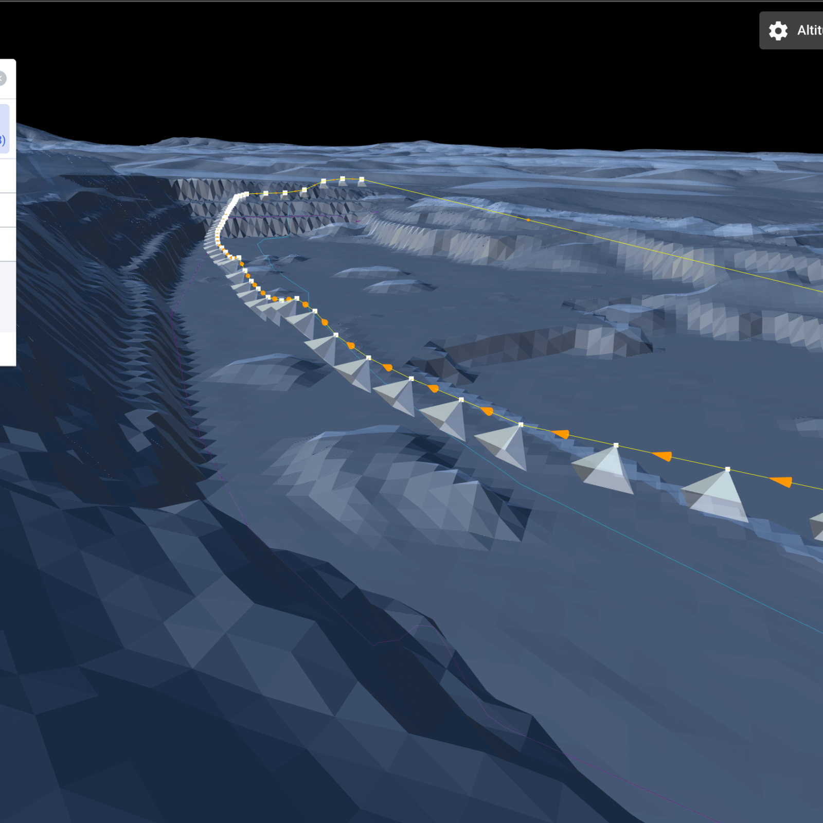
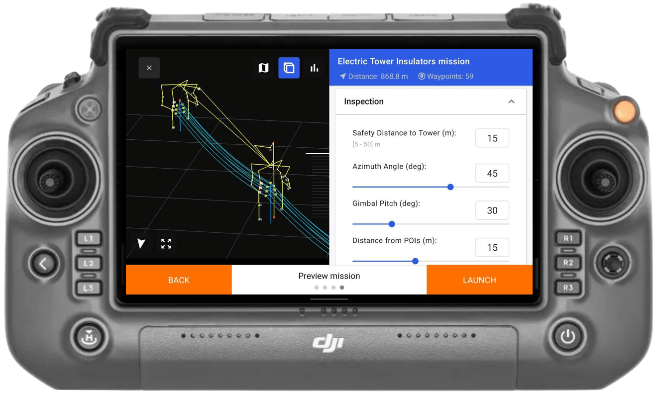
Strategically plan your drone mission with GIS-based insights for comprehensive infrastructure assessment.

2

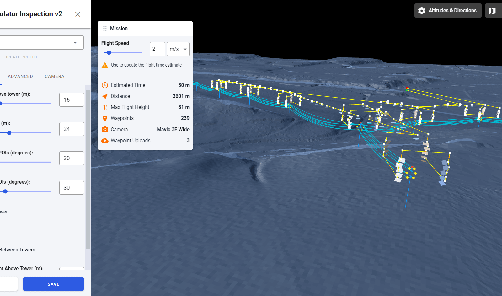
Precisely design your data collection points at an object level for targeted and efficient aerial analysis.

3

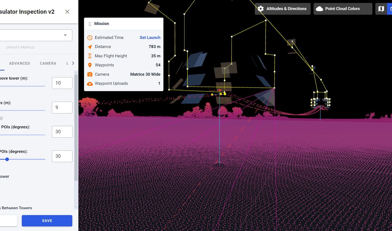
Develop your custom application within your own framework to seamlessly integrate with drone-captured data.

4

Execute your flight plan meticulously to ensure thorough coverage and high-quality data acquisition.

WRITE US

FREE TRIAL

Discover how our customized data science solutions can transform your business. Sign up for our free trial and see firsthand the impact of data-driven decision-making.

How It Works

Unleash the Power of Your Drone Imagery with HawkGrid

01

Upload Your Drone Images

Getting Started: After you contact us, we will reach out to set up your personalized storage space.
Upload Process: Easily upload your drone images to the designated storage we create for you.

02

Send Your GIS Data

Integration: We align your drone images with network objects in your GIS data.
Precision Mapping: Our system ensures accurate and useful integration for comprehensive analysis.

03

Full Access to HawkGrid Platform

Subscription-Based Service: Gain complete access to our HawkGrid platform with a monthly subscription fee.
No Initial Costs: no upfront expenses.

calculate

Estimate Your Project Expenses with Ease

Tailor Your Investment with Our Interactive Cost Calculator


Understanding the financial aspect of your drone imagery and GIS data analysis project is crucial. With our intuitive cost calculator, you can effortlessly estimate the expenses tailored to your specific needs. This tool provides a clear view of potential costs, helping you to plan and budget effectively.

Only 1 EUR per Column per Year for Comprehensive Service

We’re excited to offer you an incredibly cost-effective solution for utilizing the HAWKGRID platform. Our service stands out not just for its quality and comprehensiveness but also for its affordability. It’s important to note that full access to our platform is available at the remarkable price of just 1 EUR per column, per year.

Transparent Pricing: What you see is what you pay – no hidden fees, just straightforward and affordable service.

Calculate it!

Note: It is recommended to count 2-3 poles per kilometre on high voltage networks and 8-10 poles per kilometre on medium voltage networks.

Special corona discharge sensor for drones

Corona discharge

  • Corona is a luminous partial electrical discharge due to ionization of the air. Corona is often a sign of a defect of the electrical apparatus.
  • Corona will appear when the local electric field exceeds a critical value: Ecritical = 24-30 kV/cm
  • Pinpointing corona discharge and addressing potential equipment failure can guarantee the reliable operation of the electrical critical assets.
  • Additional effects of Corona is energy loss, electromagnetic interference, audio noises and radio interference.

Our partner is OFIL Systems

Electrical Installations’ Soft Points

ComponentPossible Issues
ConductorsDamaged, Broken Strands, Ballooning
Insulators CeramicCracked, Broken, Contaminated, Shorted
Insulators PolymericResin Leakage, Contaminated, Lost hydrophobicity, water ingress
End FittingsCorroded, Eroded
HardwareImproper Installation, Loose Fitting, Bad Connection
BushingMechanical Faults, Water ingress
Air GapsBad Sealing
GeneralBad Grounding
Foreign ObjectsShorts, Leakage
questions and answers

Frequently asked questions

If you have any question, please let us know, and we will publish the answer.

Based on the battery capacity, the drone can fly tens of kilometers based on the data provided, all in complete safety thanks to the LIDAR sensor, which makes it suitable for avoiding collisions with landmarks. However, the legal environment regulates this seriously, so the regulations in most countries only allow the drone to be kept within line of sight. Therefore, it is greatly influenced by weather conditions and topography as well.

This is a priority development at our company, so we can confidently say that this will happen soon. We have already tested the real-time error detection on quite a few objects, soon the error signal can also arrive in the central system in real time.

Yes. If we receive the GIS data and the images also contain the appropriate Exif data, we can easily integrate them into the HAWK System platform.

Our system was created specifically for the standard error type valid for all network operators. This helps us to always tailor the system to the specific needs of the given customer – the condition of which is a sufficient amount of teaching samples and a precise technical description of each error type.

other products

More products

Our other solutions that might be interesting for you.

Car detection

Electrical network inspection from land with car camera detetection. Camera system can be placed for any vehicle.

Satellite

Satellite imagery combined with AI enables you to accurately identify vegetation risks and impacts at any spot, any time.

Railway Systems

The Rail Hawk System can detect the status of objects in the railway track environment and give signals if an object needs to be repaired.